


◅
▻


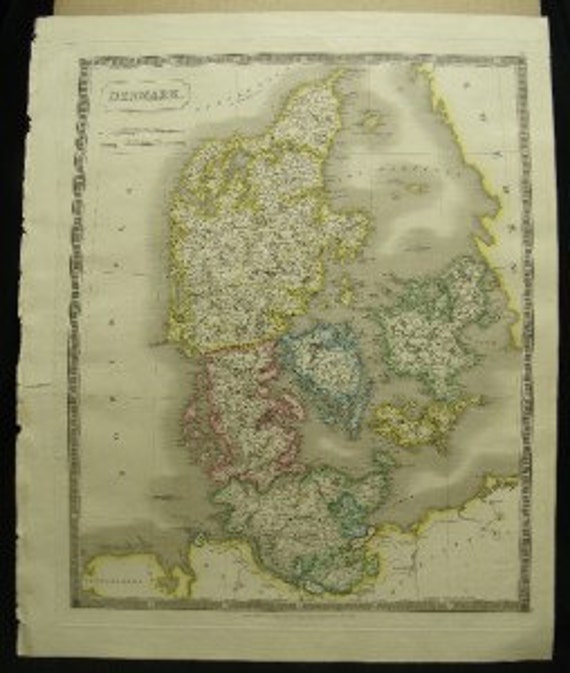
This large original map of Denmark is from Sidney Hall’s “New General Atlas” published 1828. With original hand outline coloring, this detailed map shows English and Danish
miles below the title. Published by Longman, Rees, Orme, Brown and Green, Paternoster
Row, London.
There are many details including battle sties, rivers, towns, roads, etc. The North Sea is on the left side and Sweden and the Cattlegat are shown on the right. On heavy stock
paper, the condition is considered good with just a few spots on the lower right area by
Mecklenburg.
Size and Condition
This beautiful map is surrounded by an attractive border and there is a strong platemark. There is a small tear on the left margin edge and a crease in the upper right corner. Colors
are still vivid . Overall paper size is approximately 18 ¾” x 22 ½”. This is a highly collectible 19th century map of Denmark and will be further enhanced when framed.
About the Print Dealer
This item is from the inventory of a second generation antique print dealer who literally grew up in the business. The parents of this dealer bought and sold rare prints, manuscripts and antique books for over 50 years. This highly knowledgeable dealer has continued the family tradition by buying and selling fine quality prints, maps and books and now for the first time is offering items on Ebay from an extensive inventory. All items offered for sale are original!
Returns
If there is an error in the description, please return your purchase within 14 business days to receive a full refund.
#2052
WE SHIP EVERYWHERE. If you don't see your shipping location mentioned, please send us a message and we will send you the appropriate fees.
Sidney Hall Engraved Large Antique Map Denmark Plate XV 1828
Overview
- Vintage item from the 1800s
- Materials: print, ink, paper
- Feedback: 23 reviews
- Only ships to United States from Dallas, Texas.


- Listed on May 1, 2014
- 0 views
- Seller Information
- Add item to treasury
-
No comments:
Post a Comment