


◅
▻


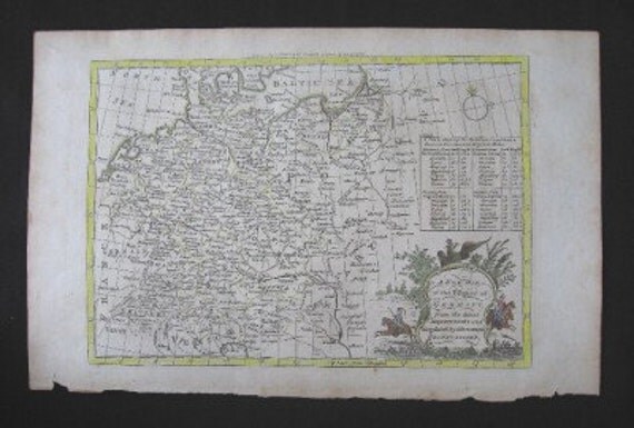
This is an original copperplate map engraving on hand laid paper. A map of Germany, it was engraved by Thomas Bowen for Middleton’s Complete System of Geography published London, 1778. Thomas Bowen was the son of noted engraver Emanuel Bowen who was an engraver of maps for George II of England and Louis XV of France.
Description
The complete title of this early map is “A New Map of the Empire of Germany from the latest Improvements and Regulated by Astronomical Observations.” A decorative map with a cartouche showing solders on horseback and an eagle with a crown it details all the sections of Germany at this time. Major rivers are shown and the borders between
neighboring countries are indicated. There is an interesting chart on the right side which shows the distances from town to town in German and English miles.
Condition and Size
The color has been added by a professional watercolorist. Condition is good with normal age toning especially on the margin areas. The overall paper size is approximately 9 ¼” x 14 ½” and the map, including the border, is approximately 7 3/4” x 11”.
About the Print Dealer
This item is from the inventory of a second generation antique print dealer who literally grew up in the business. The parents of this dealer bought and sold rare prints, manuscripts and antique books for over 50 years. This highly knowledgeable dealer has continued the family tradition by buying and selling fine quality prints, maps and books and now for the first time is offering items from an extensive inventory. All items offered for sale are original!
If there is an error in the description, please return your purchase within 7 business days to receive a full refund.
WE SHIP EVERYWHERE. If you don't see your shipping location mentioned, please send us a message and we will send you the appropriate fees.
Thomas Bowen Copperplate Engraving Map Germany 1778
Overview
- Vintage item from the 1700s
- Materials: print, paper, ink
- Feedback: 23 reviews
- Only ships to United States from Dallas, Texas.


- Listed on May 2, 2014
- 0 views
- Seller Information
- Add item to treasury
-
No comments:
Post a Comment