


◅
▻


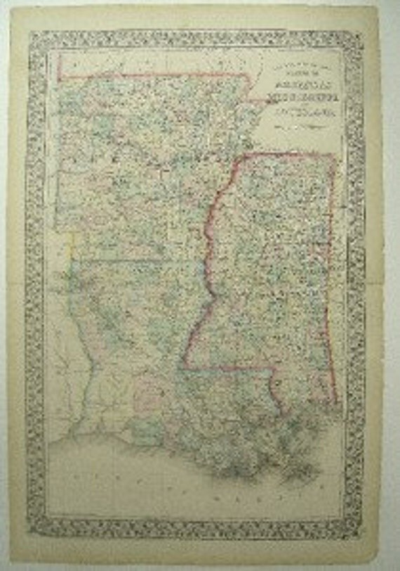
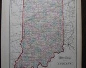
“County Map Of The States of Arkansas Mississippi and Louisiana” is a hand colored, steel lithograph from Mitchell’s NEW GENERAL ATLAS, published 1871. Samuel Augustus Mitchell and his son and successor, S. Augustus Mitchell, Jr., were very successful Philadelphia-based map publishers. Together with Joseph H. Colton’s map company in New York, the Mitchell firm dominated general map and atlas publishing in the U.S. between 1831-1890.
This atlas was produced by S. Augustus Mitchell and is highly regarded for the very vivid hand coloration, very precise engraving and size and details. The wide margins and the typical Mitchell vine leaf border are especially admired.
Map of Arkansas, Mississippi and Louisiana, Plate # 39, has original hand coloring and the different counties are shown in different colors. This heavily detailed map shows important roads, state and local boundaries, as well as and major rivers, lakes, railroads, etc.
Size and Condition
This map is in very good condition and the colors, reds, greens, blues and yellows are very vivid This double page map has a center fold and normal paper age toning. There are a few small tears in the margin areas as well as light margin soiling. Size is approximately 15.5” x 23.”
About the Print Dealer
This item is from the inventory of a second generation antique print dealer who literally grew up in the business. The parents of this dealer bought and sold rare prints, manuscripts and antique books for over 50 years. This highly knowledgeable dealer has continued the family tradition by buying and selling fine quality prints, maps and books and now for the first time is offering items from an extensive inventory. All items offered for sale are original!
#3017
WE SHIP EVERYWHERE. If you don't see your shipping location mentioned, please send us a message and we will send you the appropriate fees.
15 x 23" Large 1871 Mitchell Map Arkansas AR Mississippi MI Louisiana LA Pl #39
Overview
- Vintage item from the 1800s
- Materials: engraving, print, ink, paper
- Feedback: 23 reviews
- Only ships to United States from Dallas, Texas.


$72.50 USD
- Listed on Apr 29, 2014
- 3 views
- Seller Information
- Add item to treasury
-
No comments:
Post a Comment