


◅
▻


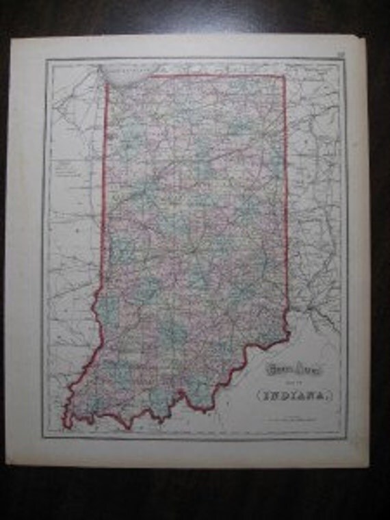
This is a very nice original hand colored map of Indiana from Gray’s Atlas of the United States, published Philadelphia, circa 1873. Gray was a civil and topographical engineer and his maps are beautifully detailed.
All the counties of Indiana are separately colored and details also include cities, railroads, rivers, etc. The state is enclosed with red outline color. On the reverse is a partial map of Illinois.
The overall size is approximately 14” x 16 ¾” and the condition is quite good. There is a small tear which is in the lower margin area and there is normal age toning. The map when framed, will be a beautiful addition to any map collection.
About the Print Dealer
This item is from the inventory of a second generation antique print dealer who literally grew up in the business. The parents of this dealer bought and sold rare prints, manuscripts and antique books for over 50 years. This highly knowledgeable dealer has continued the family tradition by buying and selling fine quality prints, maps and books and now for the first time is offering items on Ebay from an extensive inventory. All items offered for sale are original!
Shipping
Free shipping within U.S.! International buyers: when purchasing multiple prints, shipping is only charged for 1 print.
#841
Gray's Atlas Antique Map of India 1873
Overview
- Vintage item from the 1800s
- Materials: maps, paper, print, ink, pen
- Feedback: 23 reviews
- Only ships to United States from Dallas, Texas.


- Listed on Apr 29, 2014
- 0 views
- Seller Information
- Add item to treasury
-
No comments:
Post a Comment